Eastern Najdi Traditional
Saudi Arabia · Eastern Najd
The earthen vernacular building tradition of the eastern Najdi plateau, pre-20th century CE
Overview
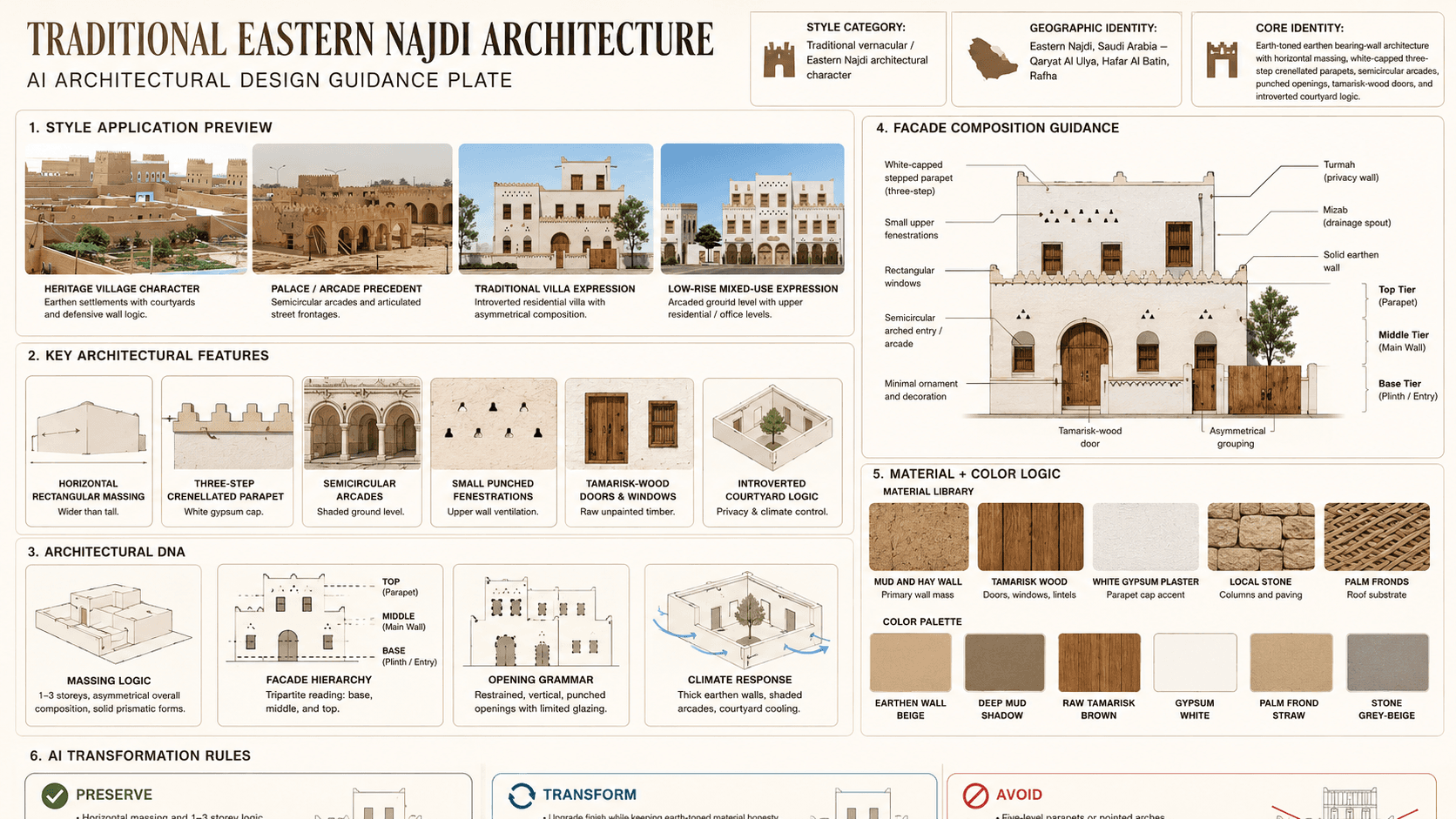
Eastern Najdi Traditional is a Saudi architectural identity rooted in Eastern Najd. Eastern Najdi Architecture (one of 19 Saudi Architecture Characters Map styles, ADG-05). Eastern stretch between the Najdi plateau and the east coast of KSA, encompassing the northern half of the Eastern Region province, anchored by Qaryat Al Ulya and Hafar Al Batin.
Visual DNA
Massing & Form
Traditional Eastern Najdi buildings are emphatically horizontal rectangular masses, with a documented width-to-height ratio of 3:1 to 6:1 — the building reads as wider than it is tall . Buildings are typically 1–3 storeys, with buildings tightly positioned and never exceeding three storeys in traditional development .
Facade Language
The facade is governed by tripartite articulation: a distinct base, middle, and top, each with its own character . The base links to the street, the middle forms the main body, and the top is where the building meets the sky .
Materials & Texture
All traditional materials are locally sourced from the region's geology and agricultural base. Mud and hay mixture: the primary wall-building material, providing thermal mass and sourced from local earth .
Color Palette
Earth-toned wall masses, gypsum white accents, and warm timber details define the palette. The building should read as desert mineral first, with ornament or painted detail working as a controlled secondary layer rather than a competing facade field.
Ornament & Detail
Ornament in Eastern Najdi is minimal — the most austere of the three Najdi sub-regions . Decorative elements are concentrated in three zones: (a) Triangulated crenellated parapets — the primary ornamental feature, a rhythmic stepped band with triangular crenellations crowning the top .
Climate Response
The Eastern Najdi climate is hot arid continental: summer temperatures reach approximately 42°C in August–September, winter lows around 15°C, with annual rainfall of only 20–55 mm . The traditional architecture responds through: (a) thick mud walls providing thermal mass that damps diurnal temperature swings; (b) intro...
Landscape & Ground
Eastern stretch between the Najdi plateau and the east coast of KSA, encompassing the northern half of the Eastern Region province, anchored by Qaryat Al Ulya and Hafar Al Batin. The Eastern Najdi climate is hot arid continental: summer temperatures reach approximately 42°C in August–September, winter lows around 15°C...
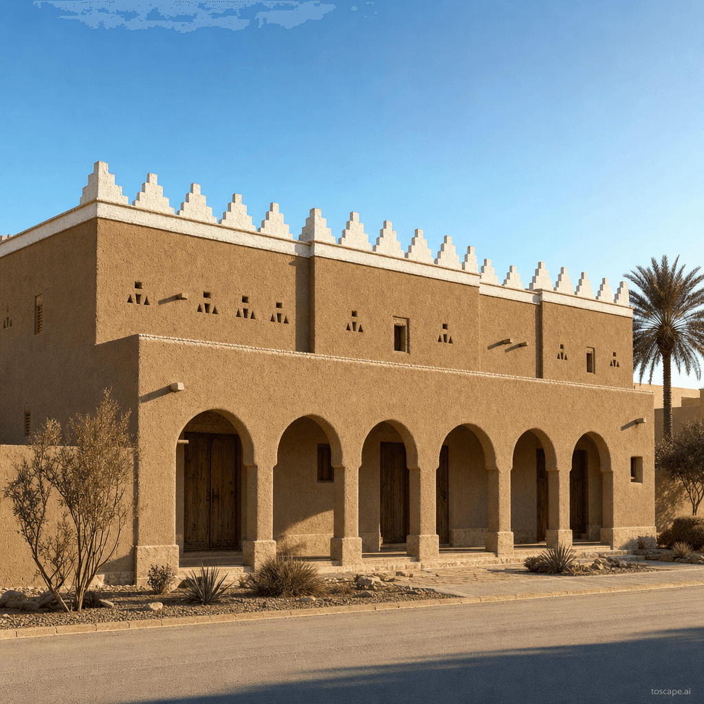
Reference elevation
Eastern Najdi Traditional — characteristic facade composition, Eastern Najd.
Context Snapshot
Traditional domestic and civic vernacular of the Eastern Najdi region (Qaryat Al Ulya, Hafar Al Batin, Rafha), pre-1950 Eastern Najdi Architecture (one of 19 Saudi Architecture Characters Map styles, ADG-05) Eastern stretch between the Najdi plateau and the east coast of KSA, encompassing the northern half of the Eastern Region province, anchored by Qaryat Al Ulya and Hafar Al Batin
Contemporary Relevance
Eastern Najdi Traditional operates as the heritage reference layer for Eastern Najd and is most useful today in conservation work, cultural tourism districts, and accurate AI rendering direction. Its value in current practice comes from preserving proportion, material hierarchy, and climate logic without flattening them into generic nostalgia.
Use this style in Toscape
Explore Eastern Najdi Traditional directly inside Toscape using the Facade Re-Style and Design Options workflows.
Open Eastern Najdi Traditional in the gallery